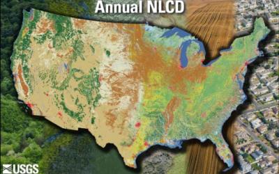
The Multi-Resolution Land Characteristics (MRLC) consortium is a group of federal agencies who coordinate and generate consistent and relevant land cover information at the national scale for a wide variety of environmental, land management and modeling applications. The creation of this consortium has resulted in the mapping of the lower 48 United States, Hawaii, Alaska and Puerto Rico into a comprehensive land cover product termed, the National Land Cover Database (NLCD), from decadal Landsat satellite imagery and other supplementary datasets.
The primary objective of the MRLC NLCD is to provide the Nation with nationally complete, current, consistent and public domain information on the Nation's land cover. Land cover information is critical for local, state and federal managers and officials to assist them with issues such as assessing ecosystem status and health, modeling nutrient and pesticide runoff, understanding spatial patterns of biodiversity, land use planning, deriving landscape pattern metrics and developing land management policies.
All MRLC NLCD data products are available at no charge to the user.