
Image
Description
Presence/absence of structural breaks in each component each year.
References Page
We are currently experiencing intermittent issues with https://www.mrlc.gov/eva. For guidance on alternative data outlets, please click here.

Published
The USDA Forest Service Geospatial Office (GO) builds and maintains the National Tree Canopy Cover (TCC) dataset as part of the National Land Cover Database (NLCD). Annual data for areas outside the contiguous United States is now available from 1985-2023. This includes Southeast Alaska, Hawaii, Puerto Rico and the U.S. Virgin Islands. The TCC datasets are derived from Landsat and Sentinel-2 imagery along with USDA Forest Service - Forest Inventory and Analysis (FIA) data, based on a spatial resolution of 30 meters. Each Tree Canopy Cover (TCC) value is determined using photo interpretation methods and machine learning models, to produce the percentage of the area covered by tree canopy and interannual change between all years.
Published
The U.S. Geological Survey has added a new outlet for Reference and Validation (R&V) data for Annual National Land Cover Database (NLCD) Conterminous U.S. (CU), Collection 1.0. In addition to availability on the USGS ScienceBase-Catalog, the R&V data are now hosted right here on MRLC.gov.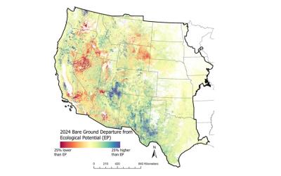
Published
A new generation of RCMAP Ecological Potential (EP) vegetation cover components are now available. Rangelands have immense inherent spatial and temporal variability, yet assessments of land condition and trends are often assessed relative to the condition of a limited number of representative points or in some cases reference data for comparison is lacking. Understanding of the potential vegetation conditions of a site in an undisturbed state is invaluable for interpreting trends, disturbance impact, and restoration targets. EP was defined as the potential fractional cover of components (bare ground, herbaceous, litter, shrub, sagebrush, and tree) in the least disturbed and most productive spaces and times of western North America since 1985. This dataset enables: 1) setting realistic expectations for restoration and management targets, 2) better understanding of the extent of vegetation departure from potential and 3) improved spatial understanding of vegetation composition and productivity variation.