Rangeland Ecological Potential - Component Cover, Cover Departure, and Vegetation States
Ecological Potential (EP) rangeland fractional cover data products represent the potential cover given the most productive, least disturbed, portion of the 1985-2024 Landsat archive. Models used to predict EP cover were trained on ecologically intact sites where annual herbaceous cover is low, no known disturbance or land treatment has occurred over the study period, and bare ground cover is relatively lower than expectations. EP data can serve as a baseline for comparison of current rangeland vegetation conditions and trends. Contemporary component cover in 2024 was compared to EP cover to generate departure maps. Additionally, we converted EP and actual cover maps for 1985 and 2024 into vegetation states These general vegetation states (native sagebrush steppe, annual grasslands, etc.) highlight locations where vegetation communities have already changed or are vulnerable to future change.
Component Definitions
Annual Herbaceous Cover
Annual Herbaceous includes grasses and forbs whose life history is complete in one growing season. This component is primarily dominated by annual invasive species including cheatgrass (Bromus tectorum), medusahead (Taeniatherum caput-medusae), red brome (Bromus rebens), or annual mustards such as tumble mustard (Sisymbrium altissimum) and tansy mustard (Descurainia pinnata). But may contain substantial native annual herbaceous vegetation at higher elevations and in California. This component is nested within Herbaceous as a secondary component. In the EP modelling, we assume annual herbaceous cover to be 0. Therefore, any occurrence of annual herbaceous is considered a positive anomaly.
Perennial Herbaceous Cover
Perennial Herbaceous consist of grasses, forbs and cacti which were photosynthetically active at any point in the year of mapping and whose lifecycle includes more than one growing season (includes biennials).
Litter Cover
Litter consists of dead standing woody vegetation and standing dead grass and forb material that was not actively photosynthesizing at any point in year of mapping. Additionally, Litter includes detached plant organic matter and biological soil crusts.
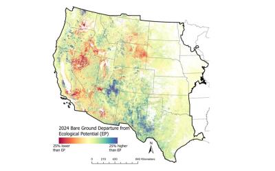
Bare Ground Cover
Bare Ground consists of exposed soil, sand, and rocks.
Sagebrush Cover
Sagebrush includes almost all species of sagebrush (Artemisia spp.) including big sagebrush (A. tridentata spp.), low sagebrush (A. arbuscula), black sagebrush (A. nova), three-tip sagebrush (A. triparta), sand sagebrush (A. filifolia), silver sagebrush (A. cana). This component is nested within Shrub as a secondary component. Excludes the low stature prairie sage (A. frigida) and white sagebrush (A. ludoviciana).
Shrub Cover
Includes all shrub species discriminated by the presence of woody stems and < 6-m in height.
Tree Cover
Tree cover includes vegetation with persistent woody stems > 6m in height. Mature stands of pinyon (Pinus spp.) and juniper (Juniperus spp.) are included regardless of height.
Departure Layers
Difference in cover values between contemporary (2024) and Ecological Potential cover. Positive values indicate higher cover in 2024 than Ecological Potential and vice versa for negative values. These departure maps are useful in highlighting locations that may have shifted from potential and those vulnerable to future transition. In the EP modelling, we assume annual herbaceous cover to be 0. Therefore, any occurrence of annual herbaceous is considered a positive anomaly.
Vegetation State
A dichotomous key was used to convert the Ecological Potential and actual cover maps for 1985 and 2024 to vegetation state types.
We derived 11 vegetation states (sparsely vegetated, annual grassland, natural perennial grassland, irrigated perennial grassland, native sagebrush steppe, invaded sagebrush steppe, sagebrush shrubland, non-sagebrush shrubland, chaparral, savannah, and forest)
* The vegetation states (Annual Grassland and Invaded Sagebrush Steppe) are not present in the Ecological Potential vegetation state. These states were omitted because Ecological Potential annual herbaceous cover was assumed to be zero.
Preferred Citation:
Rigge, M., Bunde, B., and Postma, K., 2025, Ecological Potential Fractional Component Cover Based on Long-Term Satellite Observations Across the Western United States Version 2: U.S. Geological Survey data release, https://doi.org/10.5066/P13OMU52.
Related Publications:
Rigge, M., D. Meyer, and B. Bunde. 2021. Ecological Potential Fractional Component Cover Based on Long-Term Satellite Observations Across the Western United States. Ecological Indicators. 133, p.108447 https://doi.org/10.1016/j.ecolind.2021.108447
Rigge, M., C. Homer, B. Wylie, Y. Gu, H. Shi, G. Xian, D. Meyer, B. Bunde. 2019. Using remote sensing to quantify ecosystem site potential and deviation in the Great Basin, United States. Ecological Indicators. 96: 516-531.
Rigge, M., C. Homer, H. Shi, and B. Wylie. 2020. Contemporary departures of rangeland fractional component cover from Landsat-based ecological potential in Wyoming USA. Rangeland Ecology and Management. 73: 856-870.
Data Release Citation:
Rigge, M., Bunde, B., and Postma, K., 2025, Ecological Potential Fractional Component Cover Based on Long-Term Satellite Observations Across the Western United States Version 2: U.S. Geological Survey data release, https://doi.org/10.5066/P13OMU52.