Improving information on the characteristics of land cover, understanding the basic drivers of change, and identification of potential consequences of change on human and natural systems can empower greater insight into the impacts and feedback of human activity, climate change, and other drivers. To meet its needs, the geospatial community has called for a new generation of monitoring data and information as input for many applications. Land use land cover (LULC) and land change products need to span larger geographic extents, over longer time periods, at higher spatial resolutions, and provide more systematic and consistent information on change than ever before. To help meet growing user demands, the United States Geological Survey (USGS) has developed the Annual NLCD Collection 1 Science Products.
Annual NLCD Objectives:
- Perform annual monitoring of national land cover and land change (historic and current)
- Create, validate, and distribute map products
- Establish provenance and documentation, transparency, and openness
- Use continuous R&D to enhance change detection, augment classification, reduce latency, and additional improvements
- Assess causes and consequences of change through time (assessments, projections)
Legacy NLCD
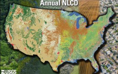
Since 1992, the National Land Cover Database (NLCD) has characterized land cover and land cover change nation-wide through processing the Landsat satellite record of the Earth. Legacy NLCD provides data at 30-meter spatial resolution, spatial reference, and descriptive data for characteristics of the land surface such as thematic class (e.g., urban, agriculture, and forest), percent impervious surface, and percent tree canopy cover. In earlier releases, NLCD has included map products across nine epochs from 2001 to 2021 (2001, 2004, 2006, 2008, 2011, 2013, 2016, 2019, and 2021).
New Collection of Annual NLCD Products
Scientists at the Earth Resources Observation and Science (EROS) Center have developed an integrated science framework to deliver annual land cover and land-cover change products with similar spatial and thematic characteristics as legacy, multi-year USGS LULC products. To provide the most relevant land cover and land cover change information for the Nation, mapped land cover (and derived products) should involve regular repeated production, updating and improvement based on robust research, and validation of land cover and land cover change.
Annual NLCD involves a new methodology using an ensemble of chained deep learning models and harmonic time series analysis. This method supports the creation of validated annual land cover and related products crossing nearly 4 decades and updated on an annual basis. Starting in 2024, USGS is producing an annual record of land cover and fractional impervious surface for the conterminous U.S. initially covering the period from 1985 to 2023. An annual strategy is planned to update the products every year. Products for other regions are planned for future releases.
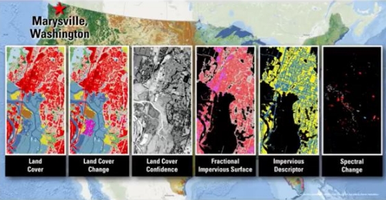
The six different Annual NLCD science products are Land Cover, Land Cover Change, Land Cover Confidence, Fractional Impervious Surface, Impervious Descriptor, and Spectral Change Day of Year. Annual NLCD Collection 1.0 covers 39 years from 1985 to 2023. The Land Cover classes are based on a modified Anderson Level II classification system.
Annual NLCD Science Products
- Land Cover (LndCov): Depicts the predominant thematic land cover class within the mapping year with respect to broad categories of artificial or natural surface cover.
- Land Cover Change (LndChg): Depicts land cover change between one product year and the next. Changes are represented in the latter year.
- Land Cover Confidence (LndCnf) : Depicts the probability value for the land cover class derived from the classification method.
- Fractional Impervious Surface (FctImp): Depicts the fractional surface area of the map unit (pixel) that is covered with artificial substrate or structures.
- Impervious Descriptor (ImpDsc): Depicts categorical data for developed land cover distinguishing roads from urban-non-road.
- Spectral Change Day of Year (SpcChg): Depicts the day-of-year (DOY) on which a significant deviation in Landsat surface reflectance was detected within the calendar year.
Documentation about the new products can be found here.
Related Citations:
Fleckenstein, R., Wellington, D.F., Jin, S., Tollerud, H.J., Brown, J.F., Dewitz, J.A., Pastick, N.J., Barber, C.P., O’Brien, A., and Spanier, M., 2026, A framework for integrating spatiotemporal deep learning methods with Landsat for annual land cover and impervious surface mapping: Remote Sensing of Environment, v. 338, article 115347, at https://doi.org/10.1016/j.rse.2026.115347.
Jin, S., Robinson, T., Dewitz, J.A., Smith, K., Danielson, P., and Postma, K., 2025, An automated compositing method for producing annual clear images from Landsat Collection 2 for annual NLCD production: International Journal of Applied Earth Observation and Geoinformation, v. 144, article 104920, at https://doi.org/10.1016/j.jag.2025.104920.
U.S. Geological Survey, 2005, Annual National Land Cover Database (NLCD) Collection 1.0 Reference Data Product: U.S. Geological Survey data release, https://doi.org/10.5066/P13EDMAF.