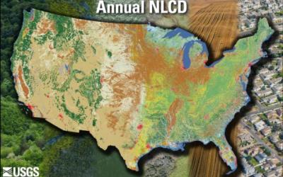
The primary NLCD land cover product represents the predominant state of the surface within the mapping year with respect to broad categories of natural and anthropogenic surface cover types.
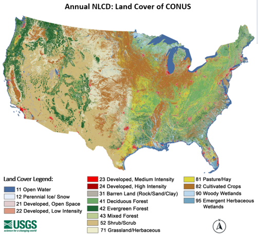
The annual NLCD land cover dataset uses a modified Anderson Level II classification system with 16 land cover classes. This classification system is derived from the original Anderson land use and land cover classification system, which was designed as a compromise among the need for compatibility with existing classification systems across U.S. federal agencies, separability using primarily remote sensing data, and logical, hierarchical relationships among classes (Anderson et al., 1976).
Annual NLCD Land Cover Legend
| Class\ Value | Classification Description |
| Water | |
| 11 | Open Water: Areas of open water, generally with less than 25% cover of vegetation or soil. |
| 12 | Perennial Ice/Snow: Areas characterized by a perennial cover of ice and/or snow, generally greater than 25% of total cover. |
| Developed | |
| 21 | Developed, Open Space: Areas with a mixture of some constructed materials, but mostly vegetation in the form of lawn grasses. Impervious surfaces account for less than 20% of total cover. These areas most commonly include large-lot single-family housing units, parks, golf courses, and vegetation planted in developed settings for recreation, erosion control, or aesthetic purposes. |
| 22 | Developed, Low Intensity: Areas with a mixture of constructed materials and vegetation. Impervious surfaces account for 20% to 49% percent of total cover. These areas most commonly include single-family housing units. |
| 23 | Developed, Medium Intensity: Areas with a mixture of constructed materials and vegetation. Impervious surfaces account for 50% to 79% of the total cover. These areas most commonly include single-family housing units. |
| 24 | Developed, High Intensity: Highly developed areas where people reside or work in high numbers. Examples include apartment complexes, row houses and commercial/industrial. Impervious surfaces account for 80% to 100% of the total cover. |
| Barren | |
| 31 | Barren Land (Rock/Sand/Clay): Areas of bedrock, desert pavement, scarps, talus, slides, volcanic material, glacial debris, sand dunes, strip mines, gravel pits and other accumulations of earthen material. Generally, vegetation accounts for less than 15% of total cover. |
| Forest | |
| 41 | Deciduous Forest: Areas dominated by trees generally greater than 5 meters tall, and greater than 20% of total vegetation cover. More than 75% of the tree species shed foliage simultaneously in response to seasonal change. |
| 42 | Evergreen Forest: Areas dominated by trees generally greater than 5 meters tall, and greater than 20% of total vegetation cover. More than 75% of the tree species maintain their leaves all year. Canopy is never without green foliage. |
| 43 | Mixed Forest: Areas dominated by trees generally greater than 5 meters tall and greater than 20% of total vegetation cover. Neither deciduous nor evergreen species are greater than 75% of total tree cover. |
| Shrubland | |
| 52 | Shrub/Scrub: Areas dominated by shrubs; less than 5 meters tall with shrub canopy typically greater than 20% of total vegetation. This class includes true shrubs, young trees in an early successional stage or trees stunted from environmental conditions. |
| Herbaceous | |
| 71 | Grassland/Herbaceous: Areas dominated by graminoid or herbaceous vegetation, generally greater than 80% of total vegetation. These areas are not subject to intensive management such as tilling but can be utilized for grazing. |
| Planted/Cultivated | |
| 81 | Pasture/Hay: Areas of grasses, legumes, or grass-legume mixtures planted for livestock grazing or the production of seed or hay crops, typically on a perennial cycle. Pasture/hay vegetation accounts for greater than 20% of total vegetation. |
| 82 | Cultivated Crops: Areas used for the production of annual crops, such as corn, soybeans, vegetables, tobacco, and cotton, and also perennial woody crops such as orchards and vineyards. Crop vegetation accounts for greater than 20% of total vegetation. This class also includes all land being actively tilled. |
| Wetlands | |
| 90 | Woody Wetlands: Areas where forest or shrubland vegetation accounts for greater than 20% of vegetative cover and the soil or substrate is periodically saturated with or covered with water. |
| 95 | Emergent Herbaceous Wetlands: Areas where perennial herbaceous vegetation accounts for greater than 80% of vegetative cover and the soil or substrate is periodically saturated with or covered with water. |
Data Access
Information about data access is available on the USGS Annual NLCD Data Access page.
Documents
Additional information on Annual NLCD and Annual NLCD science products can be found in the Science User Product Guide.
Annual NLCD Citation Information
Annual NLCD has no restrictions on the use of science products. Annual NLCD does ask that if you use the data as part of a publication or presentation that use the following citation below; however, it is not a requirement to use the data.
U.S. Geological Survey (USGS), 2024, Annual NLCD Collection 1 Science Products: U.S. Geological Survey data release, https://doi.org/10.5066/P94UXNTS
*To view and print PDFs you must obtain and install the Acrobat© Reader, available at no charge from Adobe Systems.