
Exotic species can disrupt ecosystems since they often possess competitive advantages over native species. In the western United States, the spread of exotic annual grasses (EAG) like cheatgrass (Bromus tectorum) and medusahead (Taeniatherum caput-medusae) has damaged wildlife habitats and reduced native species diversity across broad swathes of the landscape through its acceleration of the fire cycle. Application of remote sensing to capture the extent of EAG invasion across years enables managers to evaluate treatment success and strategize for defending and growing core (uninvaded) habitats. At the same time, finer temporal scale (weekly) classification of EAG cover empowers decision making on fire management and grazing. We have previously developed weekly maps of combined EAG cover for a set of common species and individual maps for especially challenging species using Harmonized Landsat Sentinel (HLS) imagery. Current data were produced with major methodological improvements compared to the previous mapping method; 1) improved HLS composites, 2) additional training data and predictor variables, 3) expanding the temporal mapping window and study area, 4) mapping concept, training data association to a point in time instead of the seasonal curve, 5) post-processing, 6) product consistency, 7) an additional component, total herbaceous, and proper nesting within the Rangeland Condition Monitoring Assessment and Projection (RCMAP) components, and 8) validation of the products with independent Analysis Inventory and Monitoring (AIM) observations. The new generation of mapping products have been developed weekly for early March-Early September of 2016-2026.
Each weekly release contains eight fractional cover maps for the following components:
Total Herbaceous*
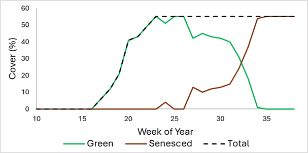
Grasses, forbs and cacti which were photosynthetically active at any point in the year of mapping.
Green Herbaceous
Grasses, forbs and cacti which were photosynthetically active during the week of mapping.
Senesced Herbaceous
Grasses, forbs and cacti which were not photosynthetically active during the week of mapping.
Total EAG*
Combined cover of: field brome (Bromus arvensis), rattlesnake brome (Bromus briziformis), rescuegrass (Bromus catharticus) Bald brome (Bromus commutatus and Bromus racemosus), ripgut brome (Bromus diandrus), soft brome (Bromus hordeaceus and Bromus hordeaceus spp. hordeaceus), Japanese brome (Bromus japonicus), compact brome (Bromus madritensis and Bromus madritensis ssp. Rubens), red brome (Bromus rubens), rye brome (Bromus secalinus), cheatgrass (Bromus tectorum), medusahead (Taeniatherum caput-medusae), and Ventenata (Ventenata dubia).
Cheatgrass*
Bromus tectorum
Field brome*
Field brome (Bromus arvensis) and Japanese brome (Bromus japonicus);
Medusahead*
Taeniatherum caput-medusae
Sandberg's bluegrass*
Poa secunda
*Indicates that weekly cover constitutes the total cover of relevant plant material that was photosynthetically active in the week of mapping or at any point year-to-date. Example trajectory of green, senesced, and total cover components:
In addition to weekly products, we derive annual data by obtaining the maximum cover value across weeks in a year by component. Weekly Herbaceous and EAG cover datasets were generated leveraging field observations from the Bureau of Land Management (BLM) AIM database and RCMAP plots, weekly HLS composites, and other relevant environmental, vegetation, remotely sensed, and geophysical drivers; and artificial intelligence/machine learning techniques. For more detail on production methods, see product metadata.
Preferred Citation:
Rigge, M., Postma, K., Dahal, D., Dornbierer, J., Megard, L., Benedict, T., and Bunde, B., 2026, Weekly Herbaceous and Exotic Annual Grass (EAG) Cover for western North America 2016 - 2026: U.S. Geological Survey database, https://doi.org/10.5066/P13QWBFH
Related Citations:
Dahal, D. and Rigge, M., 2025. Understanding the Anomalies in Exotic Annual Grass Cover in Precipitation Scenario Maps of Rangelands in the Western United States. Remote Sensing, 17(23), p.3821.
Benedict, T.D., Boyte, S.P. and Dahal, D., 2024. Differentiating Cheatgrass and Medusahead Phenological Characteristics in Western United States Rangelands. Remote Sensing, 16(22), p.4258.
Dahal, D., Boyte, S.P. and Oimoen, M.J., 2023. Predicting exotic annual grass abundance in rangelands of the western United States using various precipitation scenarios. Rangeland Ecology & Management, 90, pp.221-230.
Dahal, D., N. Pastick, S. Boyte, S. Parajuli, M. Oimoen, and L. Megard. 2022. Multi-Species Inference of Exotic Annual and Native Perennial Grasses in Rangelands of the Western United States Using Harmonized Landsat and Sentinel-2 Data. Remote Sensing 14: 807. https://doi.org/10.3390/rs14040807
Pastick, N., B. Wylie, M. Rigge, D. Dahal, S. Boyte, M. Jones, B. Allred, S. Parajuli, and Z. Wu. 2021. Rapid Monitoring of the Abundance and Spread of Exotic Annual Grasses in the Western United States Using Remote Sensing and Machine Learning. AGU advances. https://dx.doi.org/10.1029/2020AV000298.
Pastick, N., D. Dahal, B. Wylie, S. Parajuli, S. Boyte, and Z. Wu. 2020. Characterizing Land Surface Phenology and Exotic Annual Grasses in Dryland Ecosystems Using Landsat and Sentinel-2 Data in Harmony. Remote Sensing 12: 725. https://dx.doi.org/10.3390/rs12040725.
Pastick, N., B. Wylie, and Z. Wu. 2018. Spatiotemporal Analysis of Landsat-8 and Sentinel-2 Data to Support Monitoring of Dryland Ecosystems. Remote Sensing 10: 5. https://dx.doi.org/doi:10.3390/rs10050791.


