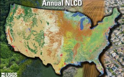
Home
Celebrating 20+ years of Partnership
Multi-Resolution Land Characteristics
Consortium

Main navigation

  • Data
    • Downloads
    • Services
  • Tools
    • MRLC NLCD EVA Tool
    • MRLC NLCD Viewer
    • MRLC Rangeland Viewer
  • Partners
  • Resources
    • FAQ
    • Publications
    • Documentation
  • About
  • Contact Us

We are currently experiencing intermittent issues with https://www.mrlc.gov/data. For guidance on alternative data outlets, please click here.

  1. Home

NLCD Tree Canopy Cover (PUERTO RICO & U.S. VIRGIN ISLANDS)

  • Read more about NLCD Tree Canopy Cover (PUERTO RICO & U.S. VIRGIN ISLANDS)

NLCD Tree Canopy Cover (PUERTO RICO & U.S. VIRGIN ISLANDS)

  • Read more about NLCD Tree Canopy Cover (PUERTO RICO & U.S. VIRGIN ISLANDS)

NLCD Tree Canopy Cover (ALASKA)

  • Read more about NLCD Tree Canopy Cover (ALASKA)

NLCD Tree Canopy Cover (ALASKA)

  • Read more about NLCD Tree Canopy Cover (ALASKA)

NLCD Tree Canopy Cover (ALASKA)

  • Read more about NLCD Tree Canopy Cover (ALASKA)

NLCD Tree Canopy Cover (ALASKA)

  • Read more about NLCD Tree Canopy Cover (ALASKA)

NLCD Tree Canopy Cover (ALASKA)

  • Read more about NLCD Tree Canopy Cover (ALASKA)

NLCD Tree Canopy Cover (ALASKA)

  • Read more about NLCD Tree Canopy Cover (ALASKA)

NLCD Tree Canopy Cover (ALASKA)

  • Read more about NLCD Tree Canopy Cover (ALASKA)

NLCD Tree Canopy Cover (ALASKA)

  • Read more about NLCD Tree Canopy Cover (ALASKA)

Pagination

  • First page « First
  • Previous page ‹ Previous
  • …
  • Page 42
  • Page 43
  • Page 44
  • Page 45
  • Current page 46
  • Page 47
  • Page 48
  • Page 49
  • Page 50
  • …
  • Next page Next ›
  • Last page Last »
Subscribe to

Search

Science Highlights

NLCD Webinar thumbnail
Article for NLCD 2019 strategy for compositing images
First page of National Land Cover Database Canopy Cover Methods document
Mapping Tree Canopy Cover Products webpage
Annual NLCD image of CONUS showing Validation Points

Annual NLCD Reference Data and Validation Metrics Now Available on MRLC

Published Sep 24, 2025

The U.S. Geological Survey has added a new outlet for Reference and Validation (R&V) data for Annual National Land Cover Database (NLCD) Conterminous U.S. (CU), Collection 1.0. In addition to availability on the USGS ScienceBase-Catalog, the R&V data are now hosted right here on MRLC.gov.
These R&V data provide Annual NLCD users with a statistical accuracy assessment of the land cover products, as well as the source reference data. This information helps users understand the accuracy of Annual NLCD and supports better decisions in research, land use planning, and resource management.

Review Products
Map of eastern CONUS with Ecological Potential data

RCMAP Ecological Potential Data Now Available

Published Jul 28, 2025

A new generation of RCMAP Ecological Potential (EP) vegetation cover components are now available. Rangelands have immense inherent spatial and temporal variability, yet assessments of land condition and trends are often assessed relative to the condition of a limited number of representative points or in some cases reference data for comparison is lacking. Understanding of the potential vegetation conditions of a site in an undisturbed state is invaluable for interpreting trends, disturbance impact, and restoration targets. EP was defined as the potential fractional cover of components (bare ground, herbaceous, litter, shrub, sagebrush, and tree) in the least disturbed and most productive spaces and times of western North America since 1985. This dataset enables: 1) setting realistic expectations for restoration and management targets, 2) better understanding of the extent of vegetation departure from potential and 3) improved spatial understanding of vegetation composition and productivity variation.

View Datasets
Annual NLCD image of CONUS showing land features

Annual NLCD CONUS Collection 1.1 Now Available

Published Jun 25, 2025

Land Cover Characteristics in a Suite of Six Products

Annual NLCD CU C1.1 adds 2024 to the established suite of six raster-based land use and land cover science products for the conterminous United States. It now covers the period between 1985 and 2024:

1. Land Cover
2. Land Cover Change
3. Land Cover Confidence
4. Fractional Impervious Surface
5. Impervious Descriptor
6. Spectral Change Day of Year

Review Products
Read More MRLC News
MRLC Logo
Follow USGS EROS
Twitter Logo USGS EROS Facebook Logo USGS EROS Instagram Logo USGS EROS Subscribe to our newsletter

Download Data

  • Annual NLCD
  • RCMAP
  • Exotic Annual Grass
  • NALCMS
  • Legacy NLCD

Analyze Data

  • Publications
  • Tools
  • Services

Resources

  • About MRLC
  • Contact Us
  • MRLC News
  • FAQs