
MRLC News
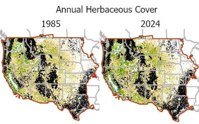
RCMAP 1985-2024 Fractional Component Time-Series Now Available
Published
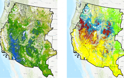
The RCMAP product suite includes 10 components: annual herbaceous, bare ground, herbaceous, litter, non-sagebrush shrub, perennial herbaceous, sagebrush, shrub, tree, and shrub height. Data characterize the percentage of each 30-meter pixel in the Western United States covered by each component for each year from 1985-2024 - providing change information for 40 years. This RCMAP update also expands mapping east to include the Great Plains and the grasslands biome.

NLCD 2021 Now Available
Published
The U.S. Geological Survey (USGS), in association with the Multi-Resolution Land Characteristics (MRLC) Consortium, is pleased to announce the completion and release of the latest epoch of the National Land Cover Database (NLCD) for the conterminous U.S.—NLCD 2021. The MRLC, a consortium of federal agencies who coordinate and generate consistent and relevant land cover information at the national scale for a wide variety of environmental, land management, and modeling applications, have been providing the scientific community with detailed land cover products for more than 30 years. Over that time, NLCD has been one of the most widely used geospatial datasets in the U.S., serving as a basis for understanding the Nation’s landscapes in thousands of studies and applications, trusted by scientists, land managers, students, city planners, and many more as a definitive source of U.S. land cover.
Release of a New Rangeland Condition, Monitoring, Assessment, and Projection (RCMAP) Time-Series Spanning 1985-2020
Published
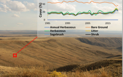
A new generation of RCMAP fractional component time-series data spanning 1985-2020 are now available for download and on the rangelands viewer. Relative to the prior generation, several key improvements are 1) additional components: perennial herbaceous and non-sagebrush shrub, 2) addition of all available BLM AIM data as training, 3) improved change detection, and 4) better imagery compositing. These factors have led to a ~15% increase in independent accuracy. Additionally, we produce error maps for each component, which reflect model uncertainty. Trends analysis products of the 1985-2020 time-series using both linear and structural change (breaks and stable states) methods will be available by July 2021. While users are encouraged to use the new generation of data, the previous version of the time-series data is archived.
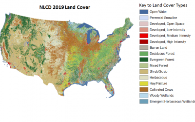
NLCD 2019 Products Now Available
Published
The NLCD 2019 suite of Conterminous U.S. (CONUS) land cover and impervious products have now been released. This release includes eight epochs of land cover (2001, 2004, 2006, 2008, 2011, 2013, 2016, and 2019), a 2001 – 2019 land cover change index, and sixteen urban imperviousness datasets - a percent imperviousness and classified imperviousness matching all years of land cover . The NLCD 2019 and 2021 products for tree canopy cover will be released in the next year. RCMAP rangeland fractional component data including a 1985-2020 time-series, projections of future component cover through the 2080s, and Ecological Potential component cover are also currently available.
Launch of the Rangeland Condition, Monitoring, Assessment, and Projection (RCMAP) Project and New Generation of Rangeland Fractional Components
Published
The USGS and Bureau of Land Management (BLM) are pleased to announce the launch of the Rangeland Condition Monitoring, Assessment, and Projection (RCMAP) project whose flagship product is a fractional component time-series. These data have been previously referred to by several names including “BIT”, “shrub-grass layers”, etc. The RCAMP time-series has been extended to 2020 using improved image composites, change detection, and inclusion of BLM Assessment, Inventory, and Monitoring (AIM) data. We have added two additional components in the current generation; perennial herbaceous and non-sagebrush shrub, in addition to the 6 components mapped previously; shrub, sagebrush, herbaceous, annual herbaceous, litter, and bare ground. The new generation of RCMAP data will be available for static download on and on the Rangelands Viewer in a few short weeks. Once the new generation is uploaded, the previous version of the time-series data will be archived at: https://doi.org/10.5066/P9C9O66W
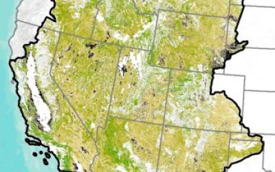
Rangeland Ecological Potential Component Cover, Cover Departure, and Vegetation States – Now Available
Published
The USGS, in collaboration with the Bureau of Land Management, has produced Ecological Potential rangeland fractional cover data for the Western U.S. These products represent the potential cover given the most productive, least disturbed, portion of the 1985-2020 Landsat archive. Contemporary component cover in 2018 was compared to Ecological Potential cover to generate departure maps. Additionally, we converted Ecological Potential and 2018 cover maps into vegetation states. These general vegetation states (native sagebrush steppe, annual grasslands, etc.) highlight locations where vegetation communities have already changed or are vulnerable to future change.

Enhanced Visualization and Analysis (EVA) Tool Now Available
Published
The MRLC Consortium, in collaboration with NOAA and the USGS, is pleased to release version 2 of the Enhanced Visualization and Analysis (EVA) tool. This tool provides users with detailed county statistics for any two NLCD landcover dates to support quick and powerful change analyses. This tool was originally developed by NOAA and shared through the consortium with custom adaptations for NLCD.

Projected NLCD Rangeland Cover Products Through 2080 – Now Available
Published
The USGS, in collaboration with the Bureau of Land Management, has produced projected rangeland fractional cover products for Western U.S. Projected data include three time periods (2020s, 2050s, and 2080s) and two climate scenarios (Representative Concentration Pathways [RCP] 4.5 and 8.5). Cover products are available for six components including shrub, sagebrush, herbaceous, annual herbaceous, litter and bare ground.
New Revised (071520) NLCD 2016 Rangeland fractional components now available
Published
The USGS in collaboration with the Bureau of Land Management and other MRLC partners has produced these revised NLCD products. Please note these new Revised (071520) rangeland products will differ from the first generation of circa 2016 fractional cover maps, a more aggressive masking of tree canopy cover was applied to each of the nine rangeland components. The component values represent the proportion of each 30 m pixel.

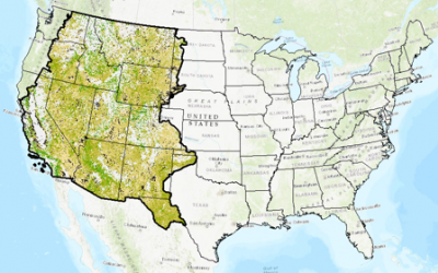
All New MRLC Rangeland Viewer Released
Published
The MRLC Rangeland Viewer provides a dynamic platform for visualization and comparison of multi-temporal geospatial data of shrub and grassland ecosystems in the Western U.S. and supports custom data subsetting and downloads.