
Home
Celebrating 20+ years of Partnership
Multi-Resolution Land Characteristics
Consortium

Main navigation

  • Data
    • Downloads
    • Services
  • Tools
    • MRLC NLCD EVA Tool
    • MRLC NLCD Viewer
    • MRLC Rangeland Viewer
  • Partners
  • Resources
    • FAQ
    • Publications
    • Documentation
    • Land Change Assessments
    • R&V
  • About
  • Contact Us
  1. Home

NLCD Tree Canopy Cover (ALASKA)

  • Read more about NLCD Tree Canopy Cover (ALASKA)

NLCD Tree Canopy Cover (ALASKA)

  • Read more about NLCD Tree Canopy Cover (ALASKA)

NLCD Tree Canopy Cover (ALASKA)

  • Read more about NLCD Tree Canopy Cover (ALASKA)

NLCD Tree Canopy Cover (ALASKA)

  • Read more about NLCD Tree Canopy Cover (ALASKA)

NLCD Tree Canopy Cover (ALASKA)

  • Read more about NLCD Tree Canopy Cover (ALASKA)

NLCD Tree Canopy Cover (ALASKA)

  • Read more about NLCD Tree Canopy Cover (ALASKA)

NLCD Tree Canopy Cover (ALASKA)

  • Read more about NLCD Tree Canopy Cover (ALASKA)

NLCD Tree Canopy Cover (ALASKA)

  • Read more about NLCD Tree Canopy Cover (ALASKA)

NLCD Tree Canopy Cover (ALASKA)

  • Read more about NLCD Tree Canopy Cover (ALASKA)

NLCD Tree Canopy Cover (ALASKA)

  • Read more about NLCD Tree Canopy Cover (ALASKA)

Pagination

  • First page « First
  • Previous page ‹ Previous
  • Page 1
  • Page 2
  • Current page 3
  • Page 4
  • Page 5
  • Page 6
  • Page 7
  • Page 8
  • Page 9
  • …
  • Next page Next ›
  • Last page Last »
Subscribe to

Search

Science Highlights

A framework for integrating spatiotemporal deep learning methods with landsat for annual land cover and impervious surface mapping

NLCD Webinar thumbnail
Article for NLCD 2019 strategy for compositing images
First page of National Land Cover Database Canopy Cover Methods document
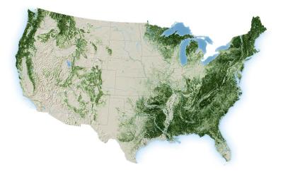
Topographic map of CONUS forestland

National Annual Tree Canopy Cover data now available from 1985-2025 for CONUS

Published Aug 04, 2026

The USDA Forest Service Geospatial Office (GO) and Research and Development - Forest Inventory and Analysis (FIA) builds and maintains the National Tree Canopy Cover (TCC) dataset as part of the National Land Cover Database (NLCD). Annual data for the contiguous United States is now available from 1985-2025. The TCC datasets are derived from Landsat and Sentinel-2 imagery along with USDA Forest Service FIA data, based on a spatial resolution of 30 meters. Each Tree Canopy Cover (TCC) value is determined using photo interpretation methods and machine learning models, to produce the percentage of the area covered by tree canopy and interannual change between all years.

Data for Southeast Alaska, Puerto Rico, and the U.S. Virgin Islands are expected to be released later in 2026.
Review Products
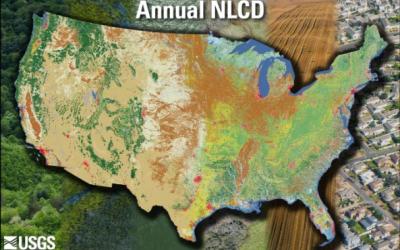
Annual NLCD image of CONUS showing land features

Annual NLCD CONUS Collection 1.2 Now Available

Published Jun 10, 2026

Land Cover Characteristics in a Suite of Six Products

Annual NLCD CU C1.2 adds 2025 to the established suite of six raster-based land use and land cover science products for the conterminous United States. It now covers the period between 1985 and 2025:

1. Land Cover
2. Land Cover Change
3. Land Cover Confidence
4. Fractional Impervious Surface
5. Impervious Descriptor
6. Spectral Change Day of Year
Review Products
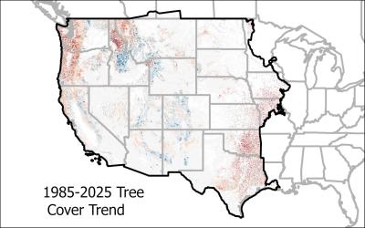
A map of Western CONUS with RCMAP Tree Cover Trend

New Generations of RCMAP and EAG Data Available

Published May 11, 2026

The U.S. Geological Survey Rangeland Condition Monitoring Assessment and Projection (RCMAP) Exotic Annual Grass (EAG) team is pleased to announce the release of a new generation of weekly resolution maps. We initially release weekly data for 2026 weeks 10-16 (March 11 – April 15) for total herbaceous, total EAG, cheatgrass, medusahead, field brome, and Sandberg’s Bluegrass. This will be followed by weekly releases through week 38 (late September) of 2026. Weeks 10-38 of 2016-2025 will also be processed and distributed in summer 2026.

A new generation of RCMAP (Rangeland Condition, Monitoring, Assessment, and Projection) fractional component time-series data spanning 1985-2025 are now available.

Both RCMAP and RCMAP-EAG data are available for download and on the rangelands viewer at www.mrlc.gov, and ArcGIS Online.

View Datasets
Rangelands Viewer
Read More MRLC News
MRLC Logo
Follow USGS EROS
Twitter Logo USGS EROS Facebook Logo USGS EROS Instagram Logo USGS EROS Subscribe to our newsletter

Download Data

  • Annual NLCD
  • RCMAP
  • Exotic Annual Grass
  • NALCMS
  • Legacy NLCD

Analyze Data

  • Publications
  • Tools
  • Services

Resources

  • About MRLC
  • Contact Us
  • MRLC News
  • FAQs
  • Land Change Assessments