
MRLC News
Historical NLCD Rangeland Cover Products Now Available
Published
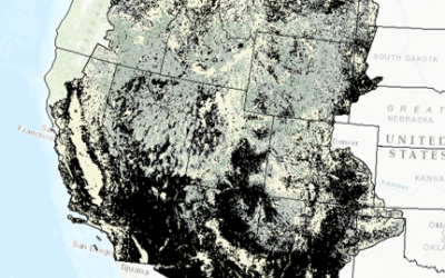
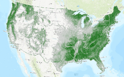
The USGS, in collaboration with the Bureau of Land Management, has produced historical NLCD Rangeland products for Western U.S. for 1985-2018. Cover products are available for six components including shrub, sagebrush, herbaceous, annual herbaceous, litter and bare ground.
NLCD 2016 Alaska Products Now Available
Published
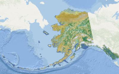
The U.S. Geological Survey (USGS) in collaboration with the MRLC consortium has released a new generation of National Land Cover Database (NLCD) products for Alaska. The 2016 Alaska Landcover includes new impervious and developed features across the state as well as updated change information products for all years. Alaska tree canopy products for the state were previously released by the U.S. Forest Service. All land cover, imperviousness and tree canopy products are now available for download here.

New NLCD 2016 Results Paper Published
Published
A new paper entitled, "Conterminous United States Land Cover Change Patterns 2001-2016 from the 2016 National Land Cover Database," has just been published in the ISPRS Journal of Photogrammetry and Remote Sensing. This paper describes the production and land change results from NLCD 2016 land cover products, and will serve as the primary citation for these products.
2015 NALCMS Land Cover Product Now Available
Published
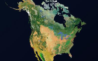
The North American Land Change Monitoring System (NALCMS) is a collaborative effort by the U.S., Mexico, and Canada to provide land cover change information for the North American continent. NALCMS has just released a new land cover product which depicts 19 classes of land cover across North America for the year 2015 at 30-meter spatial resolution. The new release represents the third product iteration, with earlier NALCMS products released for 2010 and 2005.
New Shrub and Grassland Paper Published
Published
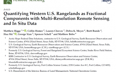
A new paper entitled, "Quantifying Western U.S. Rangelands as Fractional Components with Multi-Resolution Remote Sensing and
In Situ Data," has just been published in the journal Remote Sensing. This paper describes the production and results of NLCD shrub, herbaceous, litter, and bare ground fractional mapping products, and will serve as the primary citation for these products.
Updated NLCD 2016 Tree Canopy Cover Now Available
Published
The US Forest Service, in collaboration with the MRLC consortium, is pleased to announce the release of the NLCD 2016 tree canopy cover. With this release, the 2011 and 2016 tree canopy products, along with a 2011 to 2016 change analysis product, are now available for download. These tree canopy products have values representing the percentage of canopy cover for each 30 m pixel in the conterminous U.S., coastal Alaska, Hawaii, and Puerto Rico.
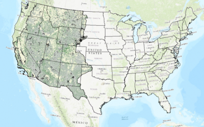
Updated NLCD 2016 Shrubland Fractional Components Now Available
Published
The USGS in collaboration with the Bureau of Land Management and other MRLC partners has produced additional NLCD products for Western U.S. shrubland areas. This suite of products contains nine components, with component values representing the proportion (fractional vegetation) of each 30 m pixel.

NLCD 2016 Tree Canopy Cover Now Available
Published
The US Forest Service, in collaboration with the MRLC consortium, is pleased to announce the release of the NLCD 2016 CONUS tree canopy cover. With this release, the 2011 and 2016 tree canopy products, along with a 2011 to 2016 change analysis product, are now available for download. These tree canopy products have values representing the percentage of canopy cover for each 30 m pixel in the conterminous U.S.
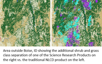
NLCD 2016 Science Research Products Now Available
Published
In May, 2019, the USGS released a new generation of the National Land Cover Database (NLCD) named NLCD 2016 for the conterminous U.S. As a follow-up to this, the USGS is now releasing three new “NLCD 2016 Science Research Products,” which represent intermediate products used in the generation of NLCD 2016 land cover. These three products include a change disturbance layer across the years 1986-2016, a disturbance date layer that relates to the current 2001 to 2016 NLCD land cover epochs, and a more comprehensive class delineation of shrub and grass classes.
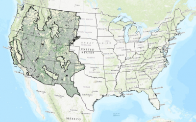
NLCD 2016 Shrubland Fractional Components Now Available
Published
The USGS in collaboration with the Bureau of Land Management and other MRLC partners has produced additional NLCD products for Western U.S. shrubland areas. This suite of products contains nine components, with component values representing the proportion (fractional vegetation) of each 30 m pixel.